Arctic Chill Threatens Snowy, Cold Thanksgiving in Vermont
Another Arctic Blast on the Way to the U.S.
An Arctic blast is heading toward the United States, bringing with it the potential for cold temperatures and snow in Vermont. The Climate Prediction Center (CPC) is forecasting a weakening of the polar vortex, which could allow cold air to move into the country. From November 25 through November 29, the focus is primarily on the middle of the country, where temperatures could dip as low as Texas.
Maureen Hastings, a meteorologist at the National Weather Service in Burlington, mentioned that Vermont might experience a "weather shift" sometime next week. She noted that colder air could arrive in Vermont on November 26 or 27, potentially bringing snow with it.
According to the CPC, there's a 40-50% chance of temperatures being below normal in New England. Hastings said that Vermont is currently expecting near-normal temperatures and near-normal to slightly above-normal precipitation.
The CPC also mentioned that around Thanksgiving and into the following weekend, cooler temperatures are expected to expand southward into parts of Texas and the Gulf States, and eastward reaching the East Coast and New England. This pattern change favors a transition to more winter-like conditions across the Northwestern, Central, and Eastern U.S., including much below normal temperatures and the potential for heavy snow.
Understanding the Polar Vortex and Other Influences
The Madden-Julian Oscillation (MJO), a moving pattern of thunderstorms in the tropics, can influence how cold or warm air shifts across the U.S. Meanwhile, La Niña, a cooling of the tropical Pacific Ocean, tends to push Arctic air farther south, increasing the chance of cold outbreaks across the northern states.
Experts have pointed out that an unusual stratospheric pattern could reshape winter weather across the Northern Hemisphere if it develops. This phenomenon, known as a sudden stratospheric warming, is described as "the largest type of disruption that occurs to the polar vortex."
Essentially, the polar vortex acts as a tight rubber band circling the North Pole in the stratosphere, keeping frigid Arctic air locked in place. When sudden stratospheric warming weakens it, that band stretches unevenly and becomes wavy, allowing lobes of cold air to slip much farther south. However, this doesn’t happen automatically — the jet stream acts as the gatekeeper, deciding where, or even if, that cold air moves.
If this occurs, it would be the first such event in November since accurate satellite records began. There were two known events in the pre-satellite era, November 1958 and 1968. Climatologist Judah Cohen, a research scientist at MIT, emphasized that if a stratospheric warming event occurs, "that would be an extraordinary, even unique event."
Vermont’s Weather Forecast for Thanksgiving
As of Thursday, November 20, there's a potential for snow on Thanksgiving in Vermont. The National Weather Service Burlington office is predicting rain to move into the region on Tuesday or Wednesday, with the potential to turn into snow on Wednesday or Thursday as the colder air mass comes down from the Arctic.
However, meteorologist Hastings warned that it's still far out and that the forecast could change before then. Across the country, AccuWeather meteorologists are predicting major travel disruptions as a storm system is set to batter much of the western United States and Midwest with heavy snow and cold rain over the holiday, while the Northeast will see mainly rain ahead of Thanksgiving Day.
On the back side of the Thanksgiving storm system, gusty winds are forecast to spread from the Great Lakes into the Northeast, impacting air travel, airports, and high-profile vehicles. Dangerously high wind gusts could affect events like the Macy’s Day Parade in New York City and the Dunkin’ Donuts Thanksgiving Day Parade in Philadelphia, grounding some balloons.
How Cold Has Vermont Been This November?
If you think the weather has been on the chilly side this month, you would be right. Hastings said that Vermont has been 3.4 degrees colder this November than average. However, she said it's not abnormally cold.
What Does the Polar Vortex Look Like Right Now?
Right now, charts show the polar vortex is unusually weak — similar to its strength in early autumn — and is likely to send temps plunging across the U.S. beginning early next week.
This weakness is linked to very low winds high above the Arctic, called zonal winds, which are now declining and approaching 0 m/s, a threshold that can trigger an event called major sudden stratospheric warming (SSW). These events often lead to significant cold outbreaks and even blizzards.
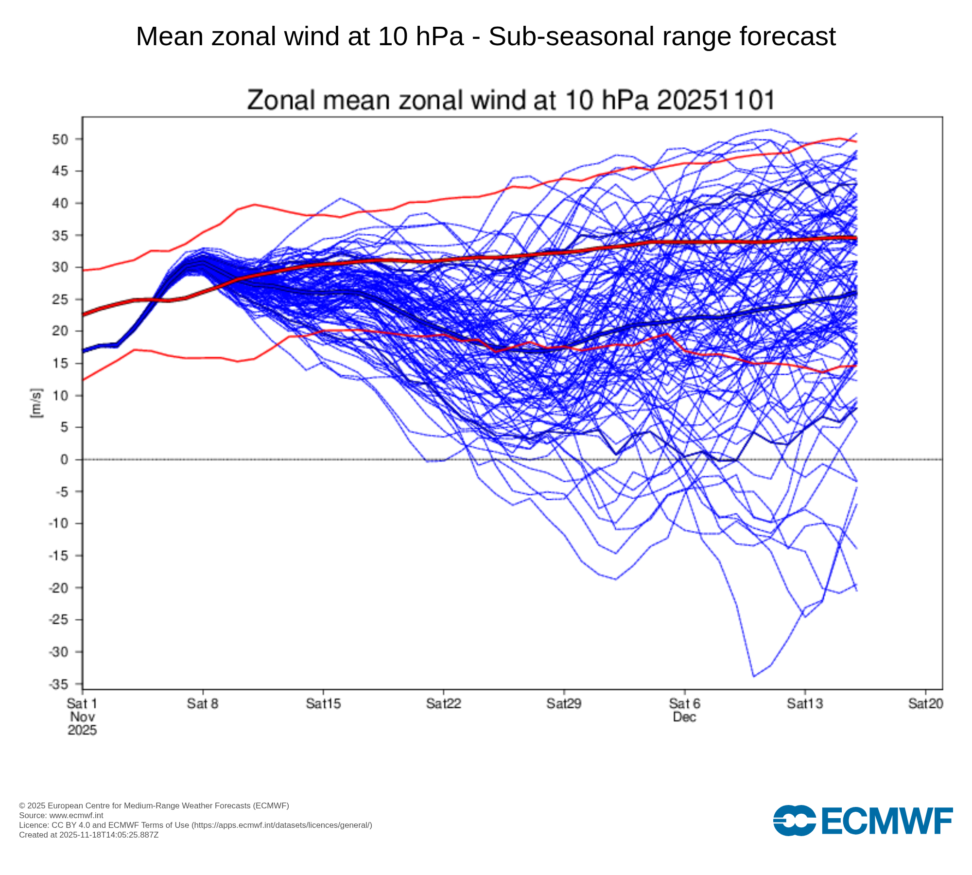
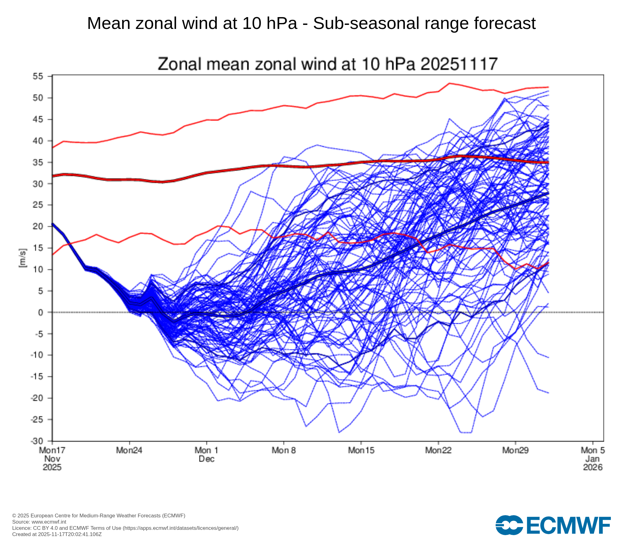
Understanding the Graphs
The dashed 0 m/s line marks the boundary between westerly winds (above the line), which represent a normal, intact stratospheric polar vortex, and easterly winds (below the line), which indicate a reversal of the vortex and meet the definition of a major sudden stratospheric warming if sustained.
In the initial graph, on November 1, the forecast members (blue lines) are at the top of the chart, signaling a strong polar vortex. In the latter graph, many forecast members (blue lines) dip toward or below 0 m/s in late November, showing the potential for a significant weakening or even reversal of the 10 hPa zonal winds, compared with the typical climatological values shown in red.
Additional Factors Affecting the Vortex
The vortex’s instability is also influenced by the Quasi-Biennial Oscillation (QBO), a stratospheric wind pattern that shifts between easterly and westerly roughly every 28–29 months. When the QBO is in its easterly phase, as it is now, the vortex is more prone to wobble south.
Meanwhile, a weak La Niña in the lower atmosphere is shaping winter patterns as well. While it doesn’t directly affect the polar vortex, it can shift the jet stream, influencing where Arctic air travels and how long cold outbreaks linger. La Niña may also leave large bodies of unfrozen, increasing the risk of lake-effect snow in the Great Lakes when Arctic air moves over open water.
Post a Comment for "Arctic Chill Threatens Snowy, Cold Thanksgiving in Vermont"
Post a Comment