
Erin Rises to Category 4 as Outer Banks Prepares for Deadly Surge
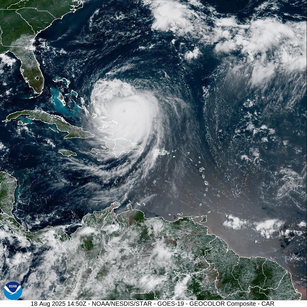
Hurricane Erin Intensifies and Threatens the East Coast
Hurricane Erin has intensified and grown in size, prompting evacuations on North Carolina's Outer Banks and warnings of life-threatening rip currents and surf conditions along the entire East Coast. After losing some intensity over the weekend, Erin strengthened back into a Category 4 storm with maximum sustained winds of 140 mph, according to a 5 p.m. advisory from the National Hurricane Center. The forecast shows the storm getting bigger and stronger as it gradually turns north on a path between the United States and Bermuda.
"The core of Erin is expected to pass to the east of the southeastern and central Bahamas today and tonight, and move between Bermuda and the East Coast of the United States by the middle of the week," the hurricane center said. The first hurricane to form this Atlantic season and the first to become a major storm, Erin was located 695 miles southwest of Bermuda and 815 miles south-southeast of Hatteras Island on Monday. The barrier island on the Outer Banks was placed under a mandatory evacuation as officials warned of possible flooding and tropical storm conditions.
Forecast and Potential Impacts
The system is expected to steer clear of the United States, though forecasters warn it could bring dangerous surf and rip current conditions to the Eastern Seaboard, all the way to Canada's Atlantic coast. According to the latest forecast, the Outer Banks face the biggest threat as coastal flooding could inundate the low-lying islands by midweek. Parts of the North Carolina coast could get wind gusts of 40 to 60 mph from late Wednesday through Thursday and waves of 10 to 15 feet on the Outer Banks, AccuWeather said.
Outside the country, a tropical storm warning was in place for the Turks and Caicos Islands as well as parts of the Bahamas, with forecasters warning of possible "flash and urban flooding." As the storm moves toward the northern Atlantic, it's expected to grow in size. By Tuesday, dangerous surf conditions are expected across the entire eastern U.S. coast, hurricane center director Michael Brennan said in a video update on the storm.
"It's not going to be a safe environment to be in the ocean," he said, adding that though the weather can be pleasant on shore, dangerous and possibly life-threatening rip currents could be lurking in the water.
Evacuation Orders and Community Response
Developments include tropical storm and storm surge watches issued for parts of the Outer Banks in the latest National Hurricane Center update. Coastal flooding may start Tuesday afternoon, more than 24 hours before tropical storm-force winds reach the area, the National Weather Service said. Emergency officials rescued at least 60 people caught in rip currents and heavy surf on Aug. 18 in Wrightsville Beach, North Carolina, prompting a "no swimming" advisory through Friday.
Erin's waves could start causing damage by Tuesday. In a video update at 5 p.m. ET, Brennan warned the Outer Banks may have to contend with 2 to 4 feet of storm surge, the increase in water level above the normal tide that often accompanies hurricanes. Even though it's on track to pass well offshore of North Carolina, Erin's considerable size presents a danger to the state and other parts of the U.S. East Coast.
Local Perspectives and Preparations
Resident: Outer Banks island empties ahead of Hurricane Erin. When news of the evacuation orders hit Hatteras Island, Fatty’s Treats & Tours was flooded with tourists complaining about having their vacations cut short, said the restaurant’s owner, Jeff Dawson. But the island started emptying overnight during what is typically the height of tourist season, and Dawson expects to close down after lunch on Monday.
Though county officials issued a mandatory evacuation order for residents beginning at 8 a.m. ET on Tuesday, Dawson plans to hunker down in his home, which is nestled in a small community in the woods of Buxton, North Carolina. He fears a tree might hit his house, but said he’s otherwise not particularly concerned about Hurricane Erin, having lived through countless storms since 1982.
Broader Impacts and Regional Concerns
Florida beaches could see waves higher than 7 feet. In Jacksonville, ocean breakers greater than seven feet are expected beginning Tuesday, according to the weather service, with the peak wave height around high tide on Wednesday. Minor coastal and tidal flooding is possible with "at least moderate beach erosion," said Angela Enyedi, a meteorologist with the National Weather Service's office in Jacksonville. The high water could inundate boat ramps, parking lots, and some campgrounds, she said.
Wave heights offshore are climbing ahead of Erin's path, as illustrated by a buoy due east of Fort Pierce, Florida, about 400 miles east-northeast of Nassau in the Bahamas, that rose to more than 18 feet Monday. Further to the north, a buoy about 258 miles south of Cape Hatteras was recording waves over six feet in height, an increase of more than a foot over wave heights on the previous day.
Evacuation Orders and Community Response
Some Outer Banks residents calm amid evacuation orders. Not everyone on the Outer Banks' Hatteras Island appeared panicked about Hurricane Erin, despite mandatory evacuation orders. Angela Tawes, co-owner of Conners Supermarket, said there were few signs of the impending storm, other than longer-than-usual lines at the gas station. "It's beautiful outside. The sky is blue. It's like 80-something degrees. There's no wind. It's gorgeous," Tawes told USA TODAY on Monday. "It's really hard for people to be thinking there's a storm coming in a couple days."
Brennan, the National Hurricane Center director, urged people not to minimize the potential for impacts along the coast, despite Erin's distance from shore. In the mid-Atlantic on Wednesday and Thursday, especially as Erin makes its closest approach to the U.S. along the Outer Banks, "breaking waves of 15 to 20 feet plus coastal flooding and storm surge could over wash dunes and flood homes and flood roads and make some communities impassable," he said.
The Storm's Growth and Historical Context
Erin is huge and getting larger. As of Monday morning, its wind field was some 397 miles in diameter. In addition, Erin is creating seas of 10 feet or more across an area roughly 500 miles in diameter. Erin ranks around the 80th percentile in terms of storm sizes of major hurricanes in the past couple of decades, John Cangialosi wrote in the National Hurricane Center's 5 a.m. ET discussion. Erin's wind field is forecast to grow over the next few days, as a cycle of eyewall replacements continues.
Some of the largest hurricanes on record include 2012's enormous Hurricane Sandy, which was among the largest known Atlantic hurricanes with a wind field spanning approximately 1,100 miles. Hurricane Floyd in 1999 was also quite large, with a diameter of 580 miles.
Evacuations and Warnings
Hurricane Erin triggers evacuations for Outer Banks islands. Two counties in North Carolina declared states of emergency and issued mandatory evacuation orders for parts of the Outer Banks, a string of low-lying islands in the Atlantic Ocean dotted with quaint villages and fishing towns. Officials for Dare and Hyde counties said Hurricane Erin is likely to cause major flooding, making it impossible to drive on Highway 12, which runs along the islands. Officials issued a mandatory evacuation for visitors in the islands of Ocracoke and Hatteras; mandatory orders for residents were set to take effect Tuesday.
"Dangerous waves, 20+ feet, will likely inundate and destroy protective dune structures along the highway," said a Hyde County news release. "Life-threatening swimming and surfing conditions are expected." The statement said "it is extremely likely" Hyde County emergency services won't be available if Highway 12 is washed over by heavy waves. "Please take this warning seriously, especially if you have medical issues or are likely to need special care," the county said.
Furthermore, the National Weather Service advised residents on the Outer Banks to consider moving their cars to higher ground.
Category 5 Hurricanes and Trends
Category 5 hurricanes not so 'rare' anymore? Erin's brief flirtation with Category 5 winds over the weekend made it the 11th Category 5 hurricane recorded in the Atlantic since 2016. That is 11 in just nine years, according to University of Oklahoma student and hurricane mapmaker Michael Ferragamo. That's the largest amount of Category 5 hurricanes recorded in a nine-year timeframe in the hurricane database (since 1851), he said.
Erin briefly exploded into Category 5 hurricane. Erin formed into a hurricane from a tropical storm on Friday. The following day, the storm quickly intensified into a Category 5 hurricane with sustained minimum winds of 160 mph before it lost momentum and was downgraded to a Category 3. Over the weekend, the storm lashed Puerto Rico and the U.S. Virgin Islands, causing tens of thousands of power outages, flight cancellations, and closures across both islands. No deaths were reported, and crews have restored power to most of the homes and businesses that experienced outages.
Even hundreds of miles offshore, hurricanes can be damaging and deadly. Hurricane Erin is expected to take a path familiar to many as the massive storm moves northward parallel to the United States coast. Dozens of hurricanes have made a similar trek in recent years, testing the nerves of millions who wait to see if the storms are destined to make any sharp left turns or wobbles toward the coast. Even when they don't brush the coast or make landfall, such storms can be deadly and cause millions of dollars of damage.
Many lives have been lost during hurricanes that remained well offshore but created rough surf or deceptive conditions that can disguise hazardous rip currents. Over 10 years, about 10 to 15% of all deaths in tropical storms and hurricanes were attributed to rip currents, according to the hurricane center.
Additional Information
Hurricane Erin caused outages across Puerto Rico, US Virgin Islands. Hurricane Erin's rainbands lashed Puerto Rico and the U.S. Virgin Islands with heavy rainfall over the weekend, resulting in power outages and temporary closures. None of the islands saw major impacts from the storm, but in Puerto Rico, over 150,000 homes and businesses lost power, most of which have been restored, according to LUMA Energy.
"When did the 2025 hurricane season begin?" The Atlantic hurricane season officially began on June 1 and lasts through the end of November. The Atlantic basin includes the Atlantic Ocean, the Caribbean Sea, and the Gulf of America, formerly known as the Gulf of Mexico. Based on a 30-year climate period from 1991 to 2020, the average Atlantic hurricane season has 14 named storms, seven hurricanes, and three major hurricanes, the National Hurricane Center said. Active hurricane weather typically peaks between mid-August and mid-October.

Post a Comment for "Erin Rises to Category 4 as Outer Banks Prepares for Deadly Surge"
Post a Comment