Tropical Storm Melissa Emerges: Spaghetti Models Show Fort Myers and Cape Coral Risk
Tropical Storm Melissa Develops in the Central Caribbean
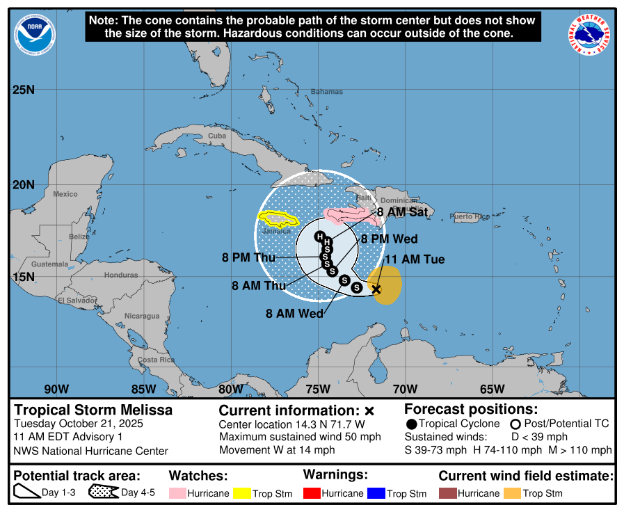
Tropical Storm Melissa formed in the central Caribbean on Tuesday, October 21, and is expected to strengthen, according to the National Hurricane Center. The storm is the 13th named storm of the 2025 Atlantic hurricane season and forecasters expect it to gradually increase in intensity as it moves northwest, then north over the next few days. However, there is significant uncertainty in the track and intensity forecast for Melissa, as noted by hurricane center forecasters.
Current Status of Tropical Storm Melissa
As of 11 a.m. on October 21, the center of the newly formed Tropical Storm Melissa was located near latitude 14.3 North, longitude 71.7 West. The storm is moving toward the west near 14 mph. A decrease in forward speed and a gradual turn to the northwest and north is expected during the next few days.
Melissa is currently located approximately 300 miles south of Port Au Prince, Haiti, and 1,047 miles southeast of Naples. Maximum sustained winds are near 50 mph, with higher gusts. The storm's surface observations and satellite data indicate that tropical-storm-force winds extend outward up to 115 miles from the center. The estimated minimum central pressure is 1003 mb.
Forecast Track and Potential Impacts
The forecast track shows the most likely path of the center of the storm. It does not illustrate the full width of the storm or its impacts, and the center of the storm is likely to travel outside the cone up to 33% of the time. On the forecast track, Melissa is expected to approach the southwestern portion of Haiti and Jamaica later this week.
Gradual strengthening is expected during the next few days. The National Hurricane Center has issued a hurricane watch for the southern coast and Tiburon peninsula of Haiti, and a tropical storm watch for Jamaica. These watches indicate that conditions could develop within the next 48 hours, and preparations should be completed by Thursday.
Possible Scenarios for Melissa
There is "significant uncertainty in the track and intensity" for Tropical Storm Melissa, according to the National Hurricane Center. Forecasters predict that Melissa will strengthen into a hurricane. Bryan Norcross, a hurricane specialist with Fox Weather, said there is some possibility of it becoming a very strong hurricane before it makes its move to the north.
"In that case, direct impacts of a major hurricane are possible on Cuba, Jamaica, Haiti, and/or somewhere in the Bahamas," Norcross said. While it is uncertain whether Melissa will impact Florida or the U.S., Norcross added that the chances of any direct effect on Florida aren't zero, but they are extremely small.
"The only way it could happen would be for Melissa to drift into the extreme western Caribbean before a dip in the jet stream moving across the U.S. came along to scoop it north," Norcross said. "There is no indication of that in the current reasonable track scenarios, however."
Rainfall and Flooding Risks
Melissa is expected to bring heavy rainfall and the risk of significant flash flooding and the danger of landslides to portions of Haiti and the Dominican Republic through the weekend. Rainfall totals of 5 to 10 inches are expected through Friday, with additional heavy rainfall possible beyond that. Areas of significant flash flooding and mudslides are possible.
Over Aruba, Puerto Rico, and Jamaica, rainfall of 1 to 3 inches is expected through Friday. Flash and urban flooding will be possible across Puerto Rico through at least Friday.
Best- and Worst-Case Scenarios
The best-case scenario, according to Norcross, is that a jet stream dip grabs Melissa and moves it quickly over the Dominican Republic or Haiti. The worst-case scenario is that it sits close enough to one or several of the mountainous Caribbean islands and dumps feet of rain, with three or four feet not out of the question.
Tracking and Preparedness
Residents in Fort Myers, Cape Coral, and Lee County, Florida, should stay informed about the storm's progress. Weather alerts via text can provide updates about current storms and weather events by location. An Air Force Hurricane Hunter aircraft is scheduled to investigate the system on Tuesday afternoon to assess the storm's strength and structure.
AccuWeather has also outlined possible scenarios for Melissa, including the potential for rough surf to the East Coast of the U.S. if the storm tracks close to the coast. There is also a medium risk of tropical rain or wind impacts across the Bahamas and South Florida from October 27 to 30.
Stay Informed
To stay updated on Tropical Storm Melissa, residents can use interactive maps to see what tropical storms and hurricanes have impacted their area in the past. Downloading the News-Press app ensures you're always connected to the news. Special subscription offers are also available for those looking to stay informed.
Post a Comment for "Tropical Storm Melissa Emerges: Spaghetti Models Show Fort Myers and Cape Coral Risk"
Post a Comment